

The "Green Line" is the demarcation line that separated Israel from the West Bank (including East Jerusalem) and the Gaza Strip from 1949 until the 1967 Six-Day War. Its creation marked the end of the 1948 Arab-Israeli War and shaped the geopolitical landscape of the region for nearly two decades. Here’s the story of how the Green Line came to be in 1949:
1. Background: The 1948 Arab-Israeli War
- May 14, 1948: The State of Israel declared independence, following the UN Partition Plan (Resolution 181) of 1947, which proposed dividing British Mandate Palestine into Jewish and Arab states. Arab leaders rejected the plan, and neighboring Arab states (Egypt, Jordan, Syria, Iraq, and Lebanon) invaded Israel the next day.
- War and Territorial Shifts: During the war, Israeli forces expanded beyond the borders proposed by the UN Partition Plan, while Jordan took control of the West Bank and East Jerusalem, and Egypt took control of the Gaza Strip.
2. The 1949 Armistice Agreements
- Early 1949: After months of fighting, both sides sought a ceasefire. The UN mediated armistice agreements between Israel and each of the Arab states.
-
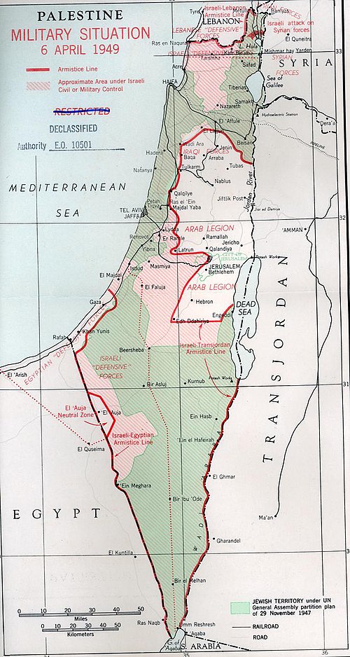
Key Agreement: Israel-Jordan Armistice (April 3, 1949):
- Signed on Rhodes, Greece, this agreement established the demarcation line between Israeli and Jordanian forces.
- The line was drawn on a map using a green pencil (hence the name "Green Line"), marking the areas controlled by Israel and Jordan at the time of the ceasefire.
- West Bank and East Jerusalem: The line placed the entire West Bank, including East Jerusalem, under Jordanian control.
- Gaza Strip: Egypt controlled the Gaza Strip, with its own armistice line with Israel.
3. Characteristics of the Green Line
- Not a Permanent Border: The armistice agreements explicitly stated that the Green Line was not a permanent border, but a temporary demarcation line until a final peace settlement could be reached.
- Based on Military Reality: The line reflected the positions of Israeli and Arab forces at the end of the war, not the borders proposed by the UN in 1947.
- Impact on Communities: The Green Line divided towns, villages, and families. For example, Jerusalem was split, with Israel controlling the western part and Jordan the eastern part, including the Old City.
4. Life Along the Green Line (1949–1967)
- Ceasefire but No Peace: The armistice agreements ended the fighting, but no formal peace treaty was signed. The Green Line became a de facto border, with limited crossings and strict controls.
- Jordanian Rule in the West Bank: Jordan annexed the West Bank in 1950, granting Jordanian citizenship to its Palestinian residents. However, this annexation was only recognized by the UK and Pakistan.
- Israeli Society: Inside Israel, the Green Line became a symbol of the country’s vulnerable borders. Many Israelis saw the line as precarious, given its narrow waist (only 9 miles wide at its thinnest point).
- Palestinian Refugees: The war and the Green Line created a refugee crisis, with hundreds of thousands of Palestinians displaced from their homes in what is now Israel.
5. The Green Line After 1967
- 1967 Six-Day War: Israel captured the West Bank, East Jerusalem, Gaza Strip, Sinai Peninsula, and Golan Heights. The Green Line became an internal administrative boundary within territory under Israeli control.
- Post-1967: The Green Line remained a reference point for negotiations and discussions about a two-state solution, with many viewing it as the basis for the borders of a future Palestinian state.
6. Legacy of the Green Line
- Symbol of Conflict: The Green Line became a powerful symbol of the Israeli-Palestinian conflict, representing both the division of the land and the unresolved nature of the dispute.
- Basis for Peace Talks: In later negotiations (e.g., Oslo Accords, Camp David Summit), the Green Line was often referenced as a starting point for discussing borders.
- Modern Israel: Today, the Green Line is still used to distinguish between Israel proper and the occupied West Bank, though Israeli settlements and infrastructure have blurred its significance on the ground.
Key Takeaways
- The Green Line was not a border, but a ceasefire line drawn in 1949 after the first Arab-Israeli war.
- It placed the West Bank and East Jerusalem under Jordanian control and the Gaza Strip under Egyptian control.
- The line was intended to be temporary, but it shaped the region’s geography and politics for nearly 20 years.
- After 1967, the Green Line became a reference point for discussions about Israeli withdrawal and Palestinian statehood.